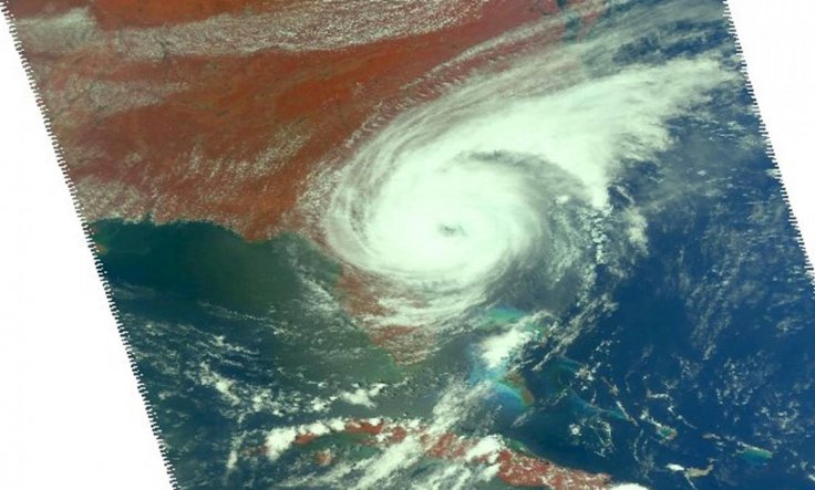
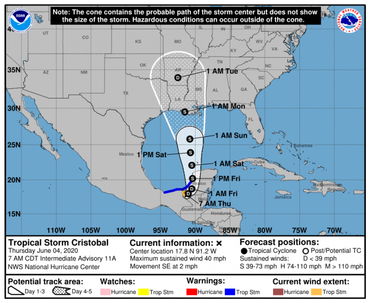
As the hurricane season in the Atlantic Ocean officially began, Tropical Storm Cristobal made landfall in southern Mexico on Wednesday, and is expected to head northward, and gain momentum over the Gulf of Mexico before making its way to the coastline of southern United States.
The confirmation of Cristobal making landfall in the state of Campeche near Atasta, Mexico was by the National Hurricane Center (NHC). The maximum sustained wind speeds were 60 mph with occasionally higher gusts.
It began as a depression in the southwestern Gulf of Mexico, over the Bay of Campeche on Monday, 1 June—which was the first day of the official hurricane season. According to forecasts, it is expected to loop over the southeastern Mexican landmass as it extends over the waters of the Bay of Campeche into Friday.

Distance From Coast Crucial
How strong the system will become will depend on how far inland or how close to the coast the storm will travel. "There is a small chance the system will break up over southern Mexico late this week, but the more likely scenario is for the storm to survive, move back out over the warm waters of the central Gulf of Mexico, reorganize, strengthen and turn northward toward the US from Friday night to Sunday night," said Dan Kottlowski, a hurricane expert with AccuWeather.
Kottlowski opined that during the week, Cristobal could ease into a tropical storm for a short while over Mexico. A further southern movement into Mexico may lead to interaction with land features such as mountains and hills, which could possibly slow down its recovery as it heads northward again.
"This stronger land interaction would cause the lower-level part of the storm to unravel, making it more difficult for it to recover once it starts to move back northward," said Kottlowski. He, however, also averred that if the storm stays closer to the coast—the source of moisture—it will hold on to its circulation. This will most likely lead to a faster rebound as it sets course towards the north during the weekend.

Expected Landfall In The US
According to Kottlowski, if the storm does not lose steam due to its interaction with Mexico, US shores could see Cristobal reaching them as a strengthened hurricane. With the possibility of Cristobal heading their way, activities such as fishing and petroleum mining in the Gulf of Mexico have been urged to follow the development of the storm closely.
In addition to that, people living or visiting coastal areas from Louisiana to Texas to Florida for vacations have also been asked to keep a close eye on Cristobal's progress. Currently, the commencement of the system's northwards turn is expected to commence on Thursday.
As of now, the anticipated window of landfall is likely to be anywhere from the upper Texas coast to the Mississippi Panhandle. This puts central Louisiana dead in the center of the window later this week or at the beginning of the next. The initial features of Cristobal have shown a slant toward a substantial amount of thunderstorms and showers on its flank in the east as against the ones in the west.
"This unbalanced heavy rainfall pattern could continue as the storm moves farther north this weekend over the eastern half of the Gulf of Mexico and adjacent shoreline areas of the US," said Mark Mancuso, Senior On-Air Meteorologist, AccuWeather.
Earliest-Ever Third Named Tropical Storm
The storm is already on a record-setting spree in the Atlantic Basin. On Tuesday, it acquired the distinction of the earliest-ever third named tropical to gather in any Atlantic hurricane season in known history.
Tropical Storm Colin held the record as it developed on 5 June 2016. Generally, it is not until significantly later into the season that a third named storm forms. On average, one occurs around August 13. This was characteristic of Tropical Storm Chantal in 2019 that developed on August 20.


