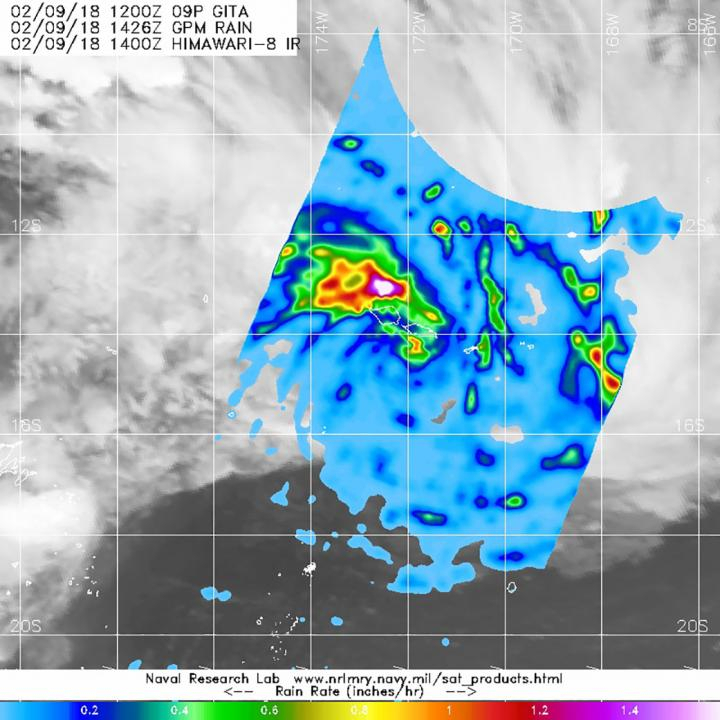
Tropical Cyclone Gita, formed near American Samoa in the Southwestern Pacific Ocean, triggering warnings since Friday, has left behind heavy rainfall in the region, found an image captured by NASA's GPM core satellite.
The Global Precipitation Measurement (GPM) mission core observatory satellite passed above Gita on Feb 9, at 9:26 a.m. EST and found heaviest rainfall from storms northwest of the center. In the northwestern quadrant, rain was falling at a rate of greater than 1 to 1.6 inches per hour, while rainfall in fragmented bands of thunderstorms east of the center were dropping up to 1 inch per hour rainfall, said the agency in a statement.
GPM, a joint mission between NASA and JAXA, found earlier on Feb 4 at 9 am EST, that the tropical Cyclone Gita was located near 14.8 south latitude and 172.3 west longitude, which is 134 nautical miles west-southwest of Pago Pago. It was last seen moving to the east at 17.2 mph with maximum sustained winds near 51.7 mph, said the statement.
The Joint Typhoon Warning Center (JTWC) has given a forecast that Gita will become a hurricane over the next day and turn southwest then west toward Tonga by Monday, Feb.12 and the storm is expected to reach the south of Fiji.
Guam Storm:
Meanwhile, tropical depression 02W formed in the Northwestern Pacific Ocean late on February 8 as NASA's Terra satellite passed overhead.
The MODIS or Moderate Resolution Imaging Spectroradiometer instrument aboard NASA's Terra satellite captured a visible image of the newly developed tropical depression 02W on Feb. 9 at 0010 UTC.
The Joint Typhoon Warning Center said the image showed "a developing low level circulation center with very little convection associated with it. The initial position is based on an AMSU [instrument] microwave image [from Feb. 9 at 6:44 a.m. EST showing weak banding and that nearly all convection has dissipated."
National Weather Service (NWS) in Guam said a Tropical Storm Watch remains in effect for Fais, Ulithi, Yap and Ngulu in Yap State, with a High surf advisory in effect until 6 a.m. local time until, with a high risk of rip currents along north and east facing reefs.
The NWS said hazardous surf of 8 to 11 feet along north facing reefs on Friday night was expected with surf falling below hazardous levels by Saturday morning and there is a small craft advisory in effect until Saturday at 6 p.m. local time.
The center of Tropical Depression 02W was located near Latitude 10.0 degrees North and Longitude 145.0 degrees East, about 240 miles south of Guam. It will continue to develop and track generally westward over the next several days passing south of the Mariana Islands and then toward Yap State and the Republic of Palau by Sunday.


